Arctic sea ice maximum at second lowest on record
- March 27, 2018
- Posted by: administrator
- Category: Environmental, Global, Arctic & Antarctica
Sea ice in the Arctic grew to its annual maximum extent last week, and joined 2015, 2016 and 2017 as the four lowest maximum extents on record, according to scientists at the NASA-supported National Snow and Ice Data Center (NSIDC) and NASA.
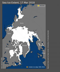
Arctic sea ice extent for March 17, 2018 was 14.48 million square kilometers (5.59 million square miles). The orange line shows the 1981 to 2010 average extent for that day.
The National Snow and Ice Data Center (NSIDC) is part of the Cooperative Institute for Research in Environmental Sciences at the University of Colorado Boulder. NSIDC scientists provide content for Arctic Sea Ice News & Analysis with partial support from NASA.
Maximum sea ice extent over Arctic Ocean for year 2nd lowest in 39-year satellite record
Sea ice over the Arctic Ocean likely reached its maximum extent for the year on March 17 at 14.48 million square kilometers (5.59 million square miles), the second lowest in the 39-year satellite record, falling just behind 2017. This year’s maximum extent is 1.16 million square kilometers (448,000 square miles) below the 1981 to 2010 average maximum of 15.64 million square kilometers (6.04 million square miles).
The four lowest seasonal maxima have all occurred during the last four years. The 2018 maximum is 60,000 square kilometers (23,200 square miles) above the record low maximum that occurred on March 7, 2017; 40,000 square kilometers (15,400 square miles) below the 2015 and 2016 maxima (now tied for third lowest); and 190,000 square kilometers (73,400 square miles) below the 2011 maximum, which is now fourth lowest.
On March 17, the Arctic sea ice cover peaked at 5.59 million square miles (14.48 million square kilometers), making it the second lowest maximum on record, at about 23,200 square miles (60,000 square kilometers) larger than the record low maximum reached on March 7, 2017.
Last four years continue decades-long trend of diminishing sea ice in Arctic
More significantly from a scientific perspective, the last four years reached nearly equally low maximum extents and continued the decades-long trend of diminishing sea ice in the Arctic. This year’s maximum extent was 448,000 square miles (1.16 million square kilometers) — an area larger than Texas and California combined – below the 1981 to 2010 average maximum extent.
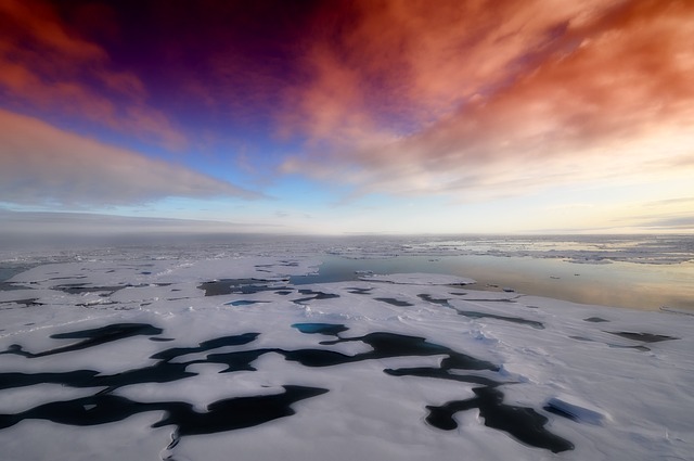
Every year, the sea ice cover blanketing the Arctic Ocean and surrounding seas thickens and expands during the fall and winter, reaching its maximum yearly extent sometime between late February and early April. The ice then thins and shrinks during the spring and summer until it reaches its annual minimum extent in September. Arctic sea ice has been declining both during the growing and melting seasons in recent decades.
Decline of Arctic sea ice cover has myriad effects, including climate change
The decline of the Arctic sea ice cover has myriad effects, from changes in climate and weather patterns to impacts on the plants and animals dependent on the ice, and to the indigenous human communities that rely on them. The disappearing ice is also altering shipping routes, increasing coastal erosion and affecting ocean circulation.
Claire Parkinson, senior climate scientist at NASA’s Goddard Space Flight Center in Greenbelt, Maryland commented:
“The Arctic sea ice cover continues to be in a decreasing trend and this is connected to the ongoing warming of the Arctic.”
“It’s a two-way street: the warming means less ice is going to form and more ice is going to melt, but also, because there’s less ice, less of the sun’s incident solar radiation is reflected off, and this contributes to the warming.”
The Arctic has gone through repeated warm episodes this winter, with temperatures climbing more than 40 degrees above average in some regions. The North Pole even experienced temperatures above the freezing point for a few days in February.
In mid-March, cooler temperatures and winds pushed out the edge of the sea ice pack and caused a late surge in ice growth that brought the maximum extent closer in line with the past few years.
February: large area of open water appeared in oldest and thickest Arctic sea ice
In February, a large area of open water appeared in the sea ice cover north of Greenland, within the multiyear ice pack — the Arctic’s oldest and thickest ice.
Most of the opening has refrozen but the new ice is expected to be thinner and more fragile, and a new opening might appear during the melt season. This could make the ice in this region more mobile and prone to exiting the Arctic this summer through either the Fram or Nares straits, ultimately melting in the warmer waters of the Atlantic Ocean.
Alek Petty, a sea ice researcher at Goddard added:
“This old, thicker ice is what we expect to provide stability to the Arctic sea ice system, since we expect that ice not to be as vulnerable to melting out as thinner, younger ice.”
“As ice in the Arctic becomes thinner and more mobile, it increases the likelihood for rapid ice loss in the summer.”
This week Operation IceBridge, NASA’s aerial survey of polar ice, is flying over the Arctic Ocean to map the distribution and thickness of sea ice.
In the fall, NASA will launch a new satellite mission, the Ice, Cloud and Land Elevation Satellite-2 (ICESat-2), which will continuously monitor how sea ice thickness is changing across the Arctic.