Copernicus warns April 2024 was the hottest on record as global temperature record streak continues
- May 8, 2024
- Posted by: Elaine Coles
- Category: Global, Europe
The EU’s Copernicus Climate Change Service (C3S) is reporting that the global temperature record streak is continuing – April 2024 was the hottest on record.
April 2024 was warmer globally than any previous April in the data record, with an average ERA5 surface air temperature of 15.03°C, 0.67°C above the 1991-2020 average for April and 0.14°C above the previous high set in April 2016.
According to Carlo Buontempo, Director of the Copernicus Climate Change Service (C3S):
“El Niño peaked at the beginning of the year and the sea surface temperatures in the eastern tropical pacific are now going back towards neutral conditions. However, whilst temperature variations associated with natural cycles like El Niño come and go, the extra energy trapped into the ocean and the atmosphere by increasing concentrations of greenhouse gases will keep pushing the global temperature towards new records.”
April 2024 – Surface air temperature and sea surface temperature highlights
This is the eleventh month in a row that is the warmest in the ERA5 data record for the respective month of the year. While unusual, a similar streak of monthly global temperature records happened previously in 2015/2016.
The month was 1.58°C warmer than an estimate of the April average for 1850-1900, the designated pre-industrial reference period.
The global-average temperature for the past 12 months (May 2023 – April 2024) is the highest on record, at 0.73°C above the 1991-2020 average and 1.61°C above the 1850-1900 pre-industrial average.
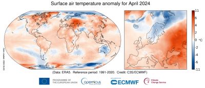
The average European temperature for April 2024 was 1.49°C above the 1991-2020 average for April, making the month the second warmest April on record for the continent.
Temperatures were most above average in eastern European regions. Fennoscandia and Iceland experienced below-average temperatures. The mean temperature, however, masks the contrast between warmer and colder temperatures experienced at the start and latter part of April in western Europe.
Outside Europe, temperatures were most above average over northern and northeastern North America, Greenland, eastern Asia, northwest Middle East, parts of South America, and most of Africa.
The El Niño in the eastern equatorial Pacific continued to weaken towards neutral conditions, but marine air temperatures in general remained at an unusually high level.
The global sea surface temperature (SST) averaged for April 2024 over 60°S–60°N was 21.04°C, the highest value on record for the month, marginally below the 21.07°C recorded for March 2024.
This is the thirteenth month in a row that the SST has been the warmest in the ERA5 data record for the respective month of the year.
April 2024 – Hydrological highlights
In April 2024, it was predominantly wetter than average over most of north-western, central and north-eastern Europe.
Most of southern Europe, including large parts of eastern Spain, peninsular Italy, the western Balkans, Türkiye, Ukraine and southern Russia, as well as Iceland, were drier than average.
In April 2024, conditions were wetter than average over regions of the central, eastern and southern North America, across Central Asia, the Persian Gulf countries, easternmost Asia, eastern Australia, southern Brazil; heavy rainfall often led to floods.
Drier-than-average conditions were seen in parts of northern Mexico, around the Caspian Sea and the Tibetan Plateau. Most of Australia was also drier than average.
April 2024 – Sea Ice highlights
Arctic sea ice extent was about 2% below average, a relatively small negative anomaly compared to the April anomalies recorded over the past 10 years.
As in March, sea ice concentration anomalies were mixed across the Arctic Ocean. Concentrations remained above average in the Greenland Sea, a persistent feature since October.
Antarctic sea ice extent was 9% below average, the 10th lowest extent for April in the satellite data record, continuing a pattern of frequent large negative anomalies observed since 2017.
As in February and March, sea ice concentrations were most below-average in the northern Weddell Sea and in the Ross-Amundsen Sea sector.
C3S is implemented by the European Centre for Medium-Range Weather Forecasts on behalf of the European Commission with funding from the EU. C3S routinely publishes monthly climate bulletins reporting on the changes observed in global surface air and sea temperatures, sea ice cover and hydrological variables.
All the reported findings are based on computer-generated analyses and according to ERA5 reanalysis dataset, using billions of measurements from satellites, ships, aircraft and weather stations around the world.