NASA warns of threat of sea level rise from melting glaciers in Antarctica
- December 13, 2018
- Posted by: administrator
- Category: Environmental, Global, Arctic & Antarctica
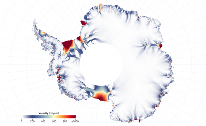
New detailed NASA maps of ice velocity and elevation show that a group of glaciers spanning one-eighth of the East Antarctica coast have begun to lose ice over the past decade, hinting at widespread changes in the ocean.
While East Antarctica has the potential to reshape coastlines around the world through sea level rise, scientists have long considered it more stable than its neighbor, West Antarctica.
In recent years, researchers have warned that Totten Glacier, a colossus that contains enough ice to raise sea levels by at least 11 feet, appears to be retreating because of warming ocean waters.
Now, researchers have found that a group of four glaciers sitting to the west of Totten, plus a handful of smaller glaciers farther east, are also losing ice.
A group of four glaciers in an area of East Antarctica called Vincennes Bay, west of the massive Totten Glacier, have lowered their surface height by about 9 feet since 2008, hinting at widespread changes in the ocean.
Catherine Walker, a glaciologist at NASA’s Goddard Space Flight Center in Greenbelt, Maryland, who presented her findings at a press conference on Monday in Washington, commented:
“Totten is the biggest glacier in East Antarctica, so it attracts most of the research focus.”
“But once you start asking what else is happening in this region, it turns out that other nearby glaciers are responding in a similar way to Totten.”
For her research, Walker used new maps of ice velocity and surface height elevation that are being created as part of a new NASA project called Inter-mission Time Series of Land Ice Velocity and Elevation, or ITS_LIVE.
Walker found that four glaciers west of Totten, in an area called Vincennes Bay, have lowered their surface height by about 9 feet since 2008 – before that year, there had been no measured change in elevation for these glaciers. Farther east, a collection of glaciers along the Wilkes Land coast have approximately doubled their rate of lowering since around 2009, and their surface is now going down by about 0.8 feet every year.
Researchers with ITS_LIVE will be launching a new initiative in early 2019 to track the movement of the world’s ice, which includes the creation of a 30-year record of satellite observations of changes in the surface elevation of glaciers, ice sheets and ice shelves, and a detailed record of variations in ice velocity starting in 2013.
While the levels of ice loss are small when compared to those of glaciers in West Antarctica, according to NASA they represent “nascent and widespread change” in East Antarctica.
Walker used simulations of ocean temperature from a model and compared them to actual measurements from sensor-tagged marine mammals. She found that recent changes in winds and sea ice have resulted in an increase to the heat delivered by the ocean waters to the glaciers in Wilkes Land and Vincennes Bay.
“Those two groups of glaciers drain the two largest subglacial basins in East Antarctica, and both basins are grounded below sea level,” Walker said. “If warm water can get far enough back, it can progressively reach deeper and deeper ice. This would likely speed up glacier melt and acceleration, but we don’t know yet how fast that would happen. Still, that’s why people are looking at these glaciers, because if you start to see them picking up speed, that suggests that things are destabilizing.”
There is a lot of uncertainty about how a warming ocean might affect the glaciers, due to how little explored the remote area of East Antarctica is. The main unknowns have to do with the topography of the bedrock below the ice and the bathymetry (shape) of the ocean floor in front of and below the ice shelves, which govern how ocean waters circulate near the continent and bring ocean heat to the ice front.
Alex Gardner, a glaciologist with NASA’s Jet Propulsion Laboratory in Pasadena, California, lead of ITS_LIVE and a participant in the press conference said:
“The change doesn’t seem random; it looks systematic.”
“And that systematic nature hints at underlying ocean influences that have been incredibly strong in West Antarctica. Now we might be finding clear links of the ocean starting to influence East Antarctica.”
“Heightened attention needs to be given to these glaciers: We need to better map the topography and we need to better map the bathymetry.”
“Only then can we be more conclusive in determining whether, if the ocean warms, these glaciers will enter a phase of rapid retreat or stabilize on upstream topographic features.”