Google and FAO launch new free Big Data tool to access key climate, environment and agricultural data
- September 22, 2020
- Posted by: administrator
- Category: Agriculture, Global, Technology & Innovation, Water Issues
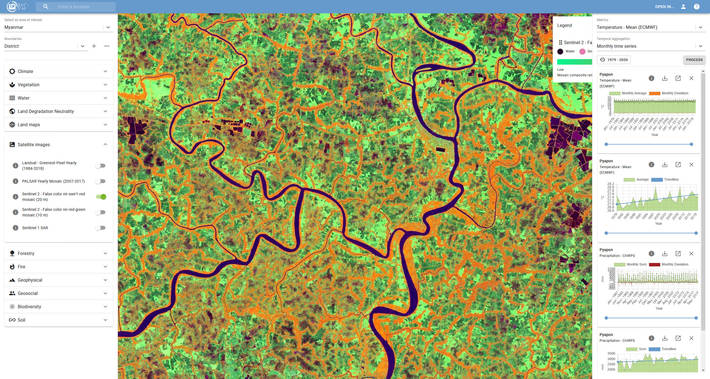
A new tool developed by Google and the Food and Agriculture Organization (FAO) of the United Nations will enable anyone anywhere to access multidimensional maps and statistics showing key climate and environmental trends wherever they are.
Earth Map empowers FAO’s Hand-in-Hand geospatial platform and allows anyone with basic Internet access to tap critical climate, environmental and agricultural information.
Earth Map is an innovative and free-to-use Web-based tool to provide efficient, rapid, inexpensive and analytically cogent insights, drawn from satellites as well as FAO’s considerable wealth of agriculturally relevant data, with a few clicks on a computer.
Earth Map has also been designed to empower and provide integrative synergies with the federated FAO’s Hand-in-Hand geospatial platform, a more comprehensive tool to provide Members, their partners and donors with the means to identify and execute highly-targeted rural development initiatives with multiple goals ranging from climate adaptation and mitigation to socio-economic resilience.
Its development follows the successful Collect Earth platform jointly developed with Google under FAO’s OpenForis suite of tools, which has already proven useful for forest assessments; land cover assessments and project design and implementation.
Commenting on the new tool, FAO Director-General QU Dongyu said:
“I am convinced that transforming our food systems to feed the world will be achieved with a digital agriculture. We need to make digital technologies accessible to everyone.”
Earth Map makes available multi-temporal and quasi real-time satellite imagery and geospatial data sets that drive Google Earth Engine and complements them with more planetary-scale analytical capabilities, allowing for detection, quantification and monitoring of changes and trends on the Earth’s surface.
It does so in a way that does not require users to master sophisticate coding techniques, thereby mitigating bottlenecks in terms of technical capacities of developing states and ultimately paving the way for smallholders to contribute to as well as access critical knowledge to sustain their livelihoods.
“At a time when environmental and societal challenges are paramount, we strive for Google’s products to enable all countries with equal access to the latest technology in support of global climate action and sustainable development,” said Rebecca Moore, Director, Google Earth. “FAO knows what information is needed, we specialize in information accessibility, and both of us are committed to boosting the resilience of people and communities worldwide.”
Areas covered include forest, crop, biodiversity conservation, pest control and water management
Google and FAO began their partnership in 2015, signing an agreement on the sidelines of the Paris Agreement. Initial efforts focused on forest and crop cover mapping techniques, and they are now rapidly extending to areas such as biodiversity conservation, pest control and water management.
Outputs from Earth Map are tailored to users’ needs, and serve as “dashboards” as well as maps, Moore notes. More than 50 countries have already benefited from the FAO-Google tools and FAO already leverages the technology to prepare and monitor projects and help Members apply for grants from entities such as the Green Climate Fund and the World Bank, including projects in Armenia, Georgia, Kazakhstan, Kyrgyzstan, Myanmar, Pakistan, the Philippines and Uzbekistan.
Supported by funding from the German Federal Ministry for the Environment, Nature Conservation and Nuclear Safety’s International Climate Initiative, Earth Map offers among else data ranging from temperature to precipitation, population, vegetation, evapotranspiration, elevation and soil.
The new tool also underscores how FAO is transforming its ownership role regarding data into a custodial sharing function to maximize beneficial use. “That’s what makes big data big, and why partnerships will have an increasingly central role in pursuing the Sustainable Development Goals,” said FAO Chief Economist Maximo Torero.
FAO will train and assist users and, while the broad focus is on ease of use – including drop-down menus and aggregated charts- and narrowing the digital divide.
The FAO can also help develop more bespoke and specialized Earth Map assessments when needed.